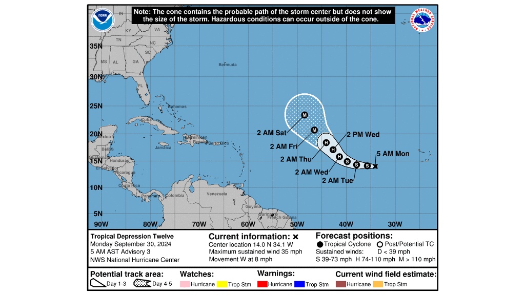
TD 12 forms in the Atlantic, set to strengthen into Hurricane Kirk

Tropical Depression (TD) 12 formed in the open Atlantic Ocean on Sunday evening.
In the 5 am advisory, the US National Hurricane Centre (NHC) said TD 12 was 1,105 kilometres west of the Cabo Verde Islands.
The storm has maximum sustained winds that are near 35 mph (55 km/h) and forecasters expect it to become a tropical storm or hurricane by Wednesday.
When that happens, the system will be named Kirk.

TD 12 is expected to become a major hurricane by Friday. It will be the third major hurricane of 2024.
Models show the storm will remain in the open Atlantic Ocean.
Meanwhile, forecasters are also paying close attention to two other systems.
The first system is located a few hundred miles south of the Cabo Verde Islands.
“Upper-level winds are forecast to become more conducive for gradual development, and a tropical depression is likely to form in a few days while it moves slowly westward over the eastern tropical Atlantic,” NHC said.
NHC has given the system an 80 per cent chance of development over the next seven days.
In the Western Caribbean Sea, a large and disorganised area of low pressure is producing some shower and thunderstorm activity.
Environmental conditions could become conducive for gradual development, and a tropical depression could form in a few days while the system is over the southern Gulf of Mexico or northwestern Caribbean Sea. While interests in the northwestern Caribbean Sea and along the US Gulf Coast should continue to monitor the progress of this system, the timetable for potential development has shifted later toward late week or this weekend,” NHC said.
NHC has given the system a 40 per cent chance of development over the next seven days.


